View Interactive Map
 View Interactive Map

|
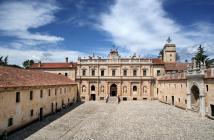
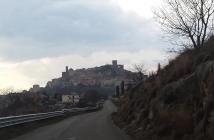
THE VALLO DI DIANO ROUTES: VIA "POPILIA"Vallo di Diano The Vallo di Diano valley - located south of the province of Salerno - is crossed by the ancient Via Popilia-Annia (today the SS 19 road) that ran from Capua to Reggio Calabria and on which in Roman times several post stations were located, as recorded by a... |
|
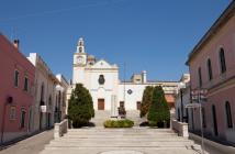
WALKING WITH MARY: The Marian cult in the Serre SalentineSerre Salentine Pilgrimages of faith and devotion to loca sancta have very ancient origins; in the Middle Ages the practice of "sacred mobility" grew significantly and has only strengthened in the intervening centuries. Alongside the peregrinationes maiores (major... |
|
GERMANIC VIA ROMEA FROM STADEL’Altra Romagna Many inhabitants of the Apennine municipalities between Romagna and Tuscany know, even just by name, the Alpe di Serra Pass (1148 m), and many have also heard about the Via Vecchia Romagnola that preceded the Mandrioli Pass (1173 m.), and possibly about the Via... |
|
THE SAN VICINIO PATHL’Altra RomagnaIn the land of the miracle-worker saint through nature and historyThe San Vicinio Path is a route in 14 stages (with 2 detours and 6 connections) for a total of almost 320 km on foot, on signposted paths, starting from Sarsina. A fascinating route... |

|
THE VIA POPILIA ROUTELa Via Popilia in Campania The famous Via Popilia is the main route crossing the LAG area of The Paths of Living Well. The LAG area of The Paths of Living Well is the result of two Local Development Systems coming together, Alburni and Ancient Volcej, and is... |
|
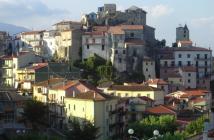
THE TANAGRO VALLEY ROUTELa Via Popilia in Campania The "Tanagro Valley Route", part of the Via Popilia route in the Campagna area, crosses the towns of Contursi Terme, Palomonte, San Gregorio Magno, Ricigliano, Romagnano al Monte, Buccino, Salvitelle, Caggiano, Auletta and ends on the Via Popilia in the Auletta area. ... |
|
THE HIGH SELE VALLEY ROUTELa Via Popilia in Campania The "High Sele Valley Route", part of the Via Popilia Route in the Campagna area, crosses the towns of Contursi Terme, Colliano, Laviano, Santomenna, Castelnuovo di Conza, Valva, Oliveto Citra, Campagna and ends on the Via Popilia in the Eboli area. It is one of the... |
|
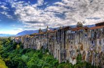
THE ALBURNI MOUNTAINS ROUTELa Via Popilia in Campania The Alburni Mountains route is one of the three secondary routes to the main Via Popilia one, and corresponds to one of the three areas into which the LAG area The Paths of Living Well can be divided. The Via Popilia route, in the Postiglione area, crosses the towns of... |
|
ON THE TRACES OF THE LONGOBARDS PATHLa Via Francigena nel territorio del Taburno The Samnite area has been since ancient times a place of conquest, and the many different peoples who have inhabited it have left behind a heritage of knowledge and flavours. Through the centuries, Samnites and Longobards shaped this area, while allowing local populations not... |
|
PILGRIM SPIRIT PATHLa Via Francigena nel territorio del Taburno The Pilgrim Spirit path, which in the Taburno area retraces the ancient local stretch of the Via Francigena, is marked and equipped along its ca. 31 km and divided into 6 stages. |