View Interactive Map
 View Interactive Map

|
GERMANIC VIA ROMEA FROM STADEL’Altra Romagna Many inhabitants of the Apennine municipalities between Romagna and Tuscany know, even just by name, the Alpe di Serra Pass (1148 m), and many have also heard about the Via Vecchia Romagnola that preceded the Mandrioli Pass (1173 m.), and possibly about the Via... |

|
THE VIA POPILIA ROUTELa Via Popilia in Campania The famous Via Popilia is the main route crossing the LAG area of The Paths of Living Well. The LAG area of The Paths of Living Well is the result of two Local Development Systems coming together, Alburni and Ancient Volcej, and is... |
|
THE TANAGRO VALLEY ROUTELa Via Popilia in Campania The "Tanagro Valley Route", part of the Via Popilia route in the Campagna area, crosses the towns of Contursi Terme, Palomonte, San Gregorio Magno, Ricigliano, Romagnano al Monte, Buccino, Salvitelle, Caggiano, Auletta and ends on the Via Popilia in the Auletta area. ... |
|
THE HIGH SELE VALLEY ROUTELa Via Popilia in Campania The "High Sele Valley Route", part of the Via Popilia Route in the Campagna area, crosses the towns of Contursi Terme, Colliano, Laviano, Santomenna, Castelnuovo di Conza, Valva, Oliveto Citra, Campagna and ends on the Via Popilia in the Eboli area. It is one of the... |
|
THE ALBURNI MOUNTAINS ROUTELa Via Popilia in Campania The Alburni Mountains route is one of the three secondary routes to the main Via Popilia one, and corresponds to one of the three areas into which the LAG area The Paths of Living Well can be divided. The Via Popilia route, in the Postiglione area, crosses the towns of... |
|
ON THE TRACES OF THE LONGOBARDS PATHLa Via Francigena nel territorio del Taburno The Samnite area has been since ancient times a place of conquest, and the many different peoples who have inhabited it have left behind a heritage of knowledge and flavours. Through the centuries, Samnites and Longobards shaped this area, while allowing local populations not... |
|
PILGRIM SPIRIT PATHLa Via Francigena nel territorio del Taburno The Pilgrim Spirit path, which in the Taburno area retraces the ancient local stretch of the Via Francigena, is marked and equipped along its ca. 31 km and divided into 6 stages. |
|
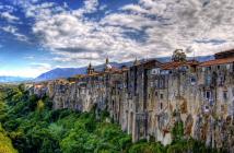
THE SLEEPING WOMAN PATHLa Via Francigena nel territorio del Taburno If the Samnite province were to be identified by one geomorphological trait, it would undoubtedly be the famous "Sleeping Woman of Sannio", which is the name by which the Taburno massif is also known, as its outlines seem to trace the stylized image of a woman who is... |
|
FRANCIGENA GREEN ROADColline Joniche - PugliaThe ancient sacred routeA route through a rich landscape, an authentic, age-old rural culture, and sites of great artistic, archaeological and anthropological interest. The Francigena Green Road is a pilgrimage route, but also a route of commerce, myths and legends... |
|
DETOUR TO FRASSINOROAppennino Modenese e Reggiano From Rovolo you can reach Frassinoro through a route, been pointed out by the "Sentieri della luce" project, that is signposted but lacks marking on the map. The detour is on a cart road near Monte Uccelliera that leads directly down to Frassinoro and Casa Giannasi. The route... |
|
THE MATILDE PATH (REGGIO EMILIA)Appennino Modenese e Reggiano This route coincides with the hiking itinerary, with the following variations: - to reach Manno after Stiano keep to the paved road that climbs to the oratory of Montecroce... |
|
THE MATILDE PATH (MODENA)Appennino Modenese e Reggiano This route coincides with the hiking itinerary, with the following variations: - to reach Manno after Stiano keep to the paved road that climbs to the oratory of Montecroce and then... |